Bureau of Land Management Visual Contrast Rating
The Bureau of Land Management's (BLM's) visual contrast rating (VCR) process assists with the planning and design of proposed actions to avoid and minimize visual contrast. The VCR process is used as the basis for conducting visual impact assessment to characterize impacts to visual resources (i.e., the landscape) and potential viewers. The outcome confirms whether the potential visual impacts from proposed surface-disturbing activities will meet the visual resource management (VRM) class objectives and allowable level of change established for the area that includes the proposed project, or if design adjustments or additional visual impact mitigation will be required.
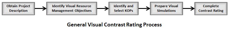
The VCR process involves a systematic comparison of the landscape's visual characteristics before and after the project is implemented, as seen from key observation points (KOPs), using the basic design elements of form, line, color, and texture. KOPs are "the most critical viewpoints," where there is public sensitivity to visual change due to the type of user, level of use, orientation to proposed project, etc., such as points or a series of points on a travel route, or at a use area or a potential use area. The VCR process is shown in the figure below.
Guidance regarding BLM's VCR process is contained in Manual 8431 - Visual Resource Contrast Rating (1986, 32 pp). Other BLM VCR documents include the following form used in the VCR process:
The VCR Process
The following steps are included within the BLM contrast rating process:
- Obtain a project description–Information about the main components and ancillary facilities of the proposed project are needed to identify and characterize contrast and associated impacts. This information usually can be obtained from a project developer or proponent. Typically, a preliminary Plan of Development is submitted with the project application. However, details such as exact layout of facilities, roads, and transmission lines are not identified, and therefore meeting with the project proponent is warranted.
- Describe the VRM objectives–For each field office or region, the BLM has developed a Resource Management Plan (RMP) that includes the VRM objectives for lands included in the RMP, usually in a GIS-generated map with polygons labeled with the applicable VRM classes. From this is drawn the existing VRM objective for the project area.
- Select KOPs–Viewpoints are selected in areas where people are present and/ or have public sensitivity from which to evaluate the visual contrast that would be created if the proposed project were built. KOPs should represent either a typical view from a sensitive viewing location or the range of impacts associated with the project. KOPs are usually located on commonly travelled routes from which the project would be visible, or other likely observation points. KOPs typically are selected through a consultation process with the BLM, and, in some cases, interested stakeholders and the public.
- Prepare visual impact simulations–Visual simulations are spatially accurate and realistic visualizations (typically computer-generated photomontages) of the project and surrounding landscape that are used to depict the overall appearance of a proposed project. Simulations depict views of the project from selected KOPs. Simulations help the BLM and other stakeholders visualize and respond to development proposals. They are also used to evaluate the effectiveness of mitigation measures to address visual impact issues.
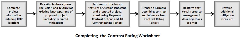
- Complete the contrast rating form–A BLM worksheet (Form 8400-4) is used to conduct and record visual contrast ratings for views from the KOPs selected for the VCR. The worksheet guides the evaluation and allows for multiple observers to evaluate a potential project. The VCR worksheet process is shown in the figure below. Contrast ratings are made by comparing the basic elements of form, line, color, and texture of the existing landscape with the proposed development, using the simulation to guide the assessment of expected future conditions. Factors to be considered when assessing visual contrast from the proposed facility include distance, angle of observation, length of time the project is in view, relative size or scale, season of use, lighting conditions, recovery time, spatial relationships, atmospheric conditions, and motion.
VCR Results
The results of the VCR for each KOP include a determination of the level of visual contrast associated with the project for each of the four design elements. One of four levels of contrast (i.e., none, weak, moderate, and strong) is assigned for each of the design elements. The contrast assessment is used as the basis for determining whether or not the proposed project conforms to the VRM objectives and allowable levels of change assigned to the area in the RMP that includes the project area. If it is determined that the project will not conform to the VRM class requirements, the VCR also specifies visual impact avoidance and mitigation measures that will be required to meet the VRM class requirements, if conformance could be achieved through mitigation. Even in situations where conformance to the VRM class objectives is confirmed, the VCR is used to identify appropriate mitigation that should be implemented to reduce visual contrast.