United States Forest Service Visual Resource Inventory Processes
The United States Department of Agriculture Forest Service (USFS) Scenery Management System (SMS) is used to inventory and analyze scenery in a national forest, to assist in establishment of overall resource goals and objectives, and to monitor scenic resources. Much of the SMS process is devoted to visual resource inventory. The SMS is described in detail in USFS Agriculture Handbook 701 Landscape Aesthetics: A Handbook for Scenery Management (1996, 264 pp). In practice, USFS has taken a flexible approach to how SMS is implemented.
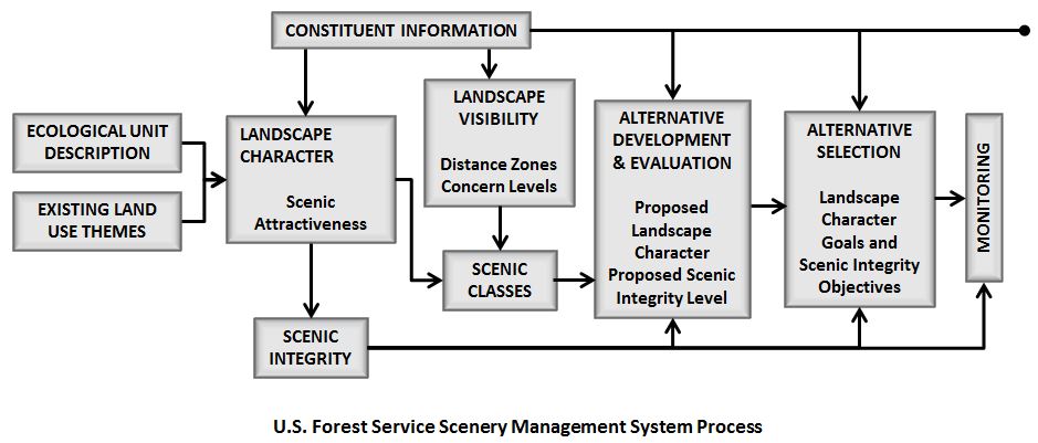
The SMS approach includes the following inventory processes:
- Landscape Character Description Development
- Scenic Attractiveness Class Development
- Existing Scenic Integrity Inventory
- Constituent Analysis
- Landscape Visibility Determination and Mapping
- Seen Areas and Distance Zones Mapping
- Scenic Class Rating
- Landscape Value Map Preparation
These processes are summarized below, and shown in the figure.
Landscape Character Description
An Ecological Unit Description (EUD), sometimes called a mapping unit description, represents the common starting point for SMS and for Ecosystem Planning. An objective description of the biological and physical elements is drawn from the EUD and combined with identified landscape character attributes to develop the Landscape Character Description. It is a combination of the scenic attributes that make each landscape identifiable or unique. Landscape Character creates a "Sense of Place," and describes the image of an area. The Landscape Character Description provides the frame of reference for defining the Scenic Attractiveness classes.
Scenic Attractiveness (ISA) Classes
Scenic Attractiveness (ISA) classes are developed to determine the relative scenic value of lands within a particular Landscape Character. The three ISA classes are: Class A, Distinctive; Class B, Typical; Class C, Indistinctive. The landscape elements of landform, vegetation, rocks, cultural features, and water features are described in terms of their line, form, color, texture, and composition for each of these classes. The classes and their breakdown are generally displayed in a chart format. A map delineating the ISA classes is prepared.
Existing Scenic Integrity Inventory
The Landscape Character description is used as a reference for the Scenic Integrity of all lands. Scenic Integrity indicates the degree of intactness and wholeness of the Landscape Character; conversely, Scenic Integrity is a measure of the degree of visible disruption of the Landscape Character. A landscape with very minimal visual disruption is considered to have high Scenic Integrity. Those landscapes having increasingly discordant relationships among scenic attributes are viewed as having diminished Scenic Integrity. Scenic Integrity is expressed and mapped in terms of Very High, High, Moderate, Low, Very Low, and Unacceptably Low.
Landscape Visibility
Landscape Visibility is composed of two parts: human values as they relate to the relative importance to the public of various scenes and the relative sensitivity of scenes based on distance from an observer. Human values that affect perceptions of landscapes are derived from constituent analysis. This information may be derived from many sources including, but not limited to independent research; other facets of ecosystem assessments; and local, regional, and national studies.
Constituent Analysis
Constituent Analysis serves as a guide to perceptions of attractiveness, helps identify special places, and helps to define the meaning people give to the subject landscape. Constituent analysis leads to a determination of the relative importance of aesthetics to the public; this importance is expressed as a Concern Level. Sites, travelways, special places, and other areas are assigned a Concern Level value of 1, 2, or 3 to reflect the relative High, Medium, or Low importance of aesthetics.
Seen Areas and Distance Zones
Seen Areas and Distance Zones are mapped from these Concern Level 1, 2, or 3 areas to determine the relative sensitivity of scenes based on their distance from an observer; these zones are identified as Foreground (up to 1/2 mile from the viewer), Middleground (up to 4 miles from the foreground), and Background (4 miles from the viewer to the horizon). Landscapes that are not visible in the Foreground, Middleground, or Background from any of the selected travelways or use areas are considered Seldom-Seen areas since they may be seen, at a minimum, from aircraft and by the occasional viewer wandering through the forest.
Scenic Class Rating
Using the data gathered and mapped for Scenic Attractiveness and Landscape Visibility, a numerical Scenic Class rating is assigned to all lands. These ratings, 1-7, indicate the relative scenic importance, or value, of discrete landscape areas. Mapped Scenic Classes are used during forest planning to compare the value of scenery with other resources, such as timber, wildlife, old-growth, or minerals.
Landscape Value Mapping
At this point in the planning process, a Landscape Value map is prepared using overlays of all the data gathered. The map provides information to planning teams concerning the relative scenic values of a subject area and the extent to which those values are intact.
The Landscape Value map is the end product of the SMS inventory, and is used in the forest planning process.
During the alternative development portion of the planning process, the potential and historical aspects of the Landscape Character Description are used to develop achievable Landscape Character Options in concert with other resource and social demands. Once a plan is adopted desired scenic integrity levels becomes official Scenic Integrity Objectives (SIOs) with associated standards and guidelines for maintaining or enhancing current conditions.