National Park Service Visual Resource Inventory
The National Park Service (NPS) Visual Resource Inventory (VRI) is a systematic process to identify scenic values and importance to NPS visitor experience and interpretive goals, for views within and extending beyond NPS units.
In the NPS VRI, the unit of inventory is a view, rather than a polygon based on physiographic properties (e.g., a valley floor or a mountain range). A view consists of a viewpoint, the viewed landscape, and the viewer. Scenic values of NPS views are based on the aesthetic qualities of the scenery and its value to the visitor experience and the NPS mission and park purpose.
The NPS VRI includes two primary processes that lead to ratings for scenic quality and view importance: the scenic quality assessment and the view importance assessment.
- The scenic quality assessment process identifies and describes visible elements of the viewed landscape and rates the scenic quality of the view.
- TThe view importance assessment identifies and describes key attributes of the viewpoint, viewed landscape, and viewers in addition to rating the importance of the view to NPS and the visitor experience.
These processes are discussed in more detail below, and shown in the diagram.
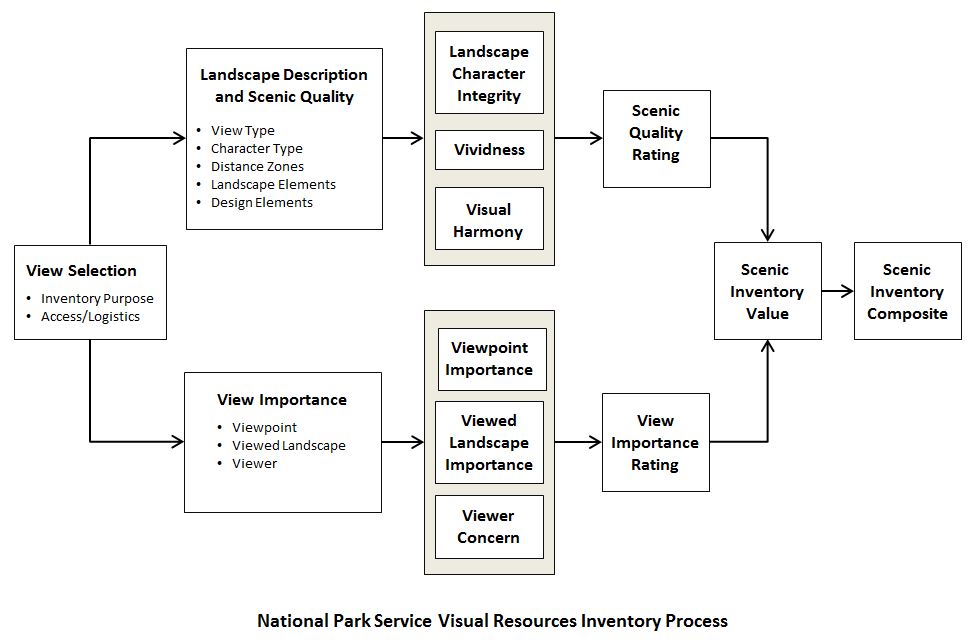
Based on the outcomes of the scenic quality assessment and the view importance assessment, the viewed landscapes are assigned a scenic inventory value (SIV) from very low to very high. The views are mapped using a Geographic Information System, and the SIVs for overlapping views are combined to create composite SIVs that can be used by NPS to identify scenic conservation objectives for the viewed landscapes.
Documentation of NPS's VRI process is under development; however, the VRI process is described in more detail in the following publication: Documenting America's Scenic Treasures: The National Park Service Visual Resource Inventory (2016, 26 pp). Other NPS VRI documents include the following data sheets and instructions used in the VRI process:
- Viewpoint Identification Worksheet (optional)
- View Description & Scenic Quality Data
- Scenic Quality Individual Rating Data
- View Description & Scenic Quality Data Instructions
- View Importance Data
- View Importance Rating Guide
- View Importance Data - Instructions
Other documents related to the NPS VRI include:
- National Park Service Visual Resource Inventory Fact Sheet
- The National Park Service Visual Resource Inventory: Incorporating Historic and Cultural Values into Scenic Resource Inventories
Landscape Description and Scenic Quality Assessment
The landscape description and scenic quality assessment component of the NPS VRI inventory process includes a field-based description of the visual elements in the viewed landscape, and an assessment of scenic quality of the view. The field team typically consists of park staff and/or park volunteers and may also include other stakeholders or partners. The landscape description part of the process records basic data about the viewpoint and observation, as well as recording the visible landscape elements of the view. The data are descriptive, not evaluative. Data collected about the viewed landscape include view boundaries; view type; predominant landscape character type; landforms, landcover, land uses, and structures; and prominent design elements. Photographs of the viewed landscape are also taken and recorded.
The scenic quality assessment follows the landscape description. For purposes of the inventory, scenic quality is rated by assessing three factors: landscape character integrity, vividness, and visual harmony. For each factor, there are three components, and raters assign a rating of 1-5 for each component, using a rating guide. The component ratings are combined into factor ratings, and the factor ratings are combined into an overall scenic quality rating for the view. After individuals rate the view independently, the team discusses the component ratings and arrives at a consensus rating for each component. The consensus-derived component ratings are then combined to assign a single value for the scenic quality rating. The ratings fall into five classes, from A to E. Class A views have the highest scenic quality and Class E the lowest.
View Importance Assessment
The view importance assessment is an office-based assessment that identifies NPS and visitor values for the view through a rating process for each of the view components. As part of the process, key descriptive information about the viewpoint and viewed landscape is gathered that helps inform the rating process.
Information collected about the viewpoint identifies whether the location is associated with designated scenic or historic cultural features or locations, such as National Scenic or Historic Trails, designated scenic overlooks, historic properties, cultural landscapes or other specially designated areas. Similar information is identified for the viewed landscape so that it is clear whether the landscape in the view-whether inside or outside the park-includes special features or designations that are important to the park and its visitors.
The view importance rating process assigns a numeric rating to three view importance factors: viewpoint importance, viewed landscape importance, and viewer concern. The assessment is performed by an interdisciplinary team that could include staff from natural and cultural resources, interpretation, operations, and law enforcement. Similar to the scenic quality rating, the view importance assessment evaluates three equally weighted components for each view importance factor. The final rating for each component is determined through discussion and consensus. View importance ratings fall into five classes from 1 to 5. Class 1 views have the highest view importance and Class 5 the lowest.
SIV Determination and View Mapping
For a given view, the scenic quality rating and view importance are combined into a binary value that is the SIV, but also expressed as a value ranging from Very Low (VL) to Very High (VH). For example, a view with high scenic quality and moderate view importance would have an SIV of A-3 High (H). The SIV is the final visual resource value for an individual view (relative to other inventoried views) that is recorded in the VRI spatial database for further interpretation, analysis, and visualization.
Using the data from the landscape description, inventoried views are mapped in a geographic information system (GIS), and the SIV is assigned to the view in the GIS.
Composite SIV Determination
Frequently, inventoried views will overlap, that is, an area within the viewed landscape may be visible from two or more inventoried viewpoints. To account for such areas of overlap, the inventory process determines a composite scenic inventory value (composite SIV). Where viewsheds overlap, scenic quality and view importance ratings are combined to generate a new composite SIV that reflects the highest ratings of scenic quality and view importance within the overlapping views. Composite SIVs are derived using a geospatial analysis in the GIS by mapping visible areas from each viewpoint (i.e., viewsheds) and combining them to identify and map areas of multiple view overlap.
VRI Database
The information gathered in the inventory process is stored in a geospatial database available to NPS staff. The geospatial database includes web-based data input and reporting capabilities.