BLM’s Visual Resource Inventory
The BLM’s Visual Resource Inventory (VRI) is a systematic process for:
- Assessing and rating the intrinsic scenic quality of a particular tract of land, through the Scenic Quality Rating process;
- Measuring the public concern for the scenic quality of the tract, through the Sensitivity Level Analysis; and
- Classifying the distance from which the landscape is most commonly viewed, through delineation of Distance Zones.
The Scenic Quality Rating process, the Sensitivity Level Analysis, and the Distance Zone delineation process are discussed in more detail below, and shown in the figure below.
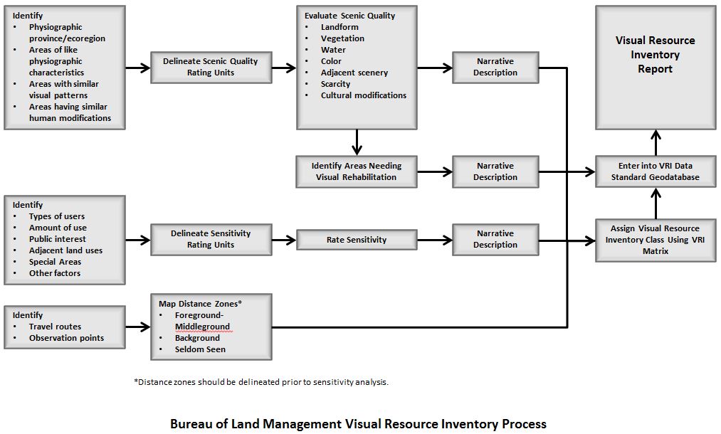
Based on the outcome of the VRI, BLM-administered lands are assigned to one of four VRI classes which spatially delineate the general distribution of relative visual resource values. VRI Class I is reserved for special areas where a management decision to preserve the natural landscape condition preceded the land use planning process. VRI Class II, III and IV are the result of the three VRI factors being evaluated in combination to assign a VRI Class. VRI Class II lands have the greatest relative visual value, and VRI Class IV lands have the lowest relative visual value. The VRI class values and the individual VRI factors serve as the primary source of information for the Visual Resource Management (VRM) Class decisions in BLM Resource Management Plans (RMPs); they are the basic measure of the quality of the visual resource, which must be considered when determining VRM objectives in the RMP process. VRI values should also be discussed when describing the visual impacts of a proposed surface-disturbing action.
Guidance regarding BLM’s VRI process is contained in BLM Manual 8410 - Visual Resource Inventory (Issued 1986, 28 pp). Other BLM VRI documents include the following forms used in the VRI process:
- BLM Form 8400-1 Scenic Quality Field Inventory Form (MS Word) (PDF)
- BLM Form 8400-5 Scenic Quality Rating Summary Form (MS Word) (PDF)
- BLM Form 8400-6 Sensitivity Level Rating Sheet (MS Word) (PDF)
Scenic Quality Rating
Within the VRI process, public lands are evaluated with regard to their scenic quality, defined as the visual appeal of a particular tract of land. Scenic quality is determined systematically by
- dividing the landscape into Scenic Quality Rating Units (SQRUs) based on conspicuous changes in physiography or land use, and
- ranking scenic quality within each SQRU based on the assessment of seven key factors: landform, vegetation, water, color, adjacent scenery, scarcity, and cultural modifications.
The ratings are made in the field by trained observers who evaluate the landscape view from inventory observation points, which are either important viewpoints or points with views that are representative of the SQRU. Based on the outcome of this assessment, lands within each SQRU are assigned a scenic value rating of A (high scenic value), B (moderate scenic value), or C (low scenic value). Generally, those areas with the most variety and most harmonious composition have the highest scenic value ratings, while areas with less variety and greater levels of disturbance from human activities have the lowest scenic value ratings.
Sensitivity Level Analysis
Visual sensitivity is defined as a measure of public concern for scenic quality. Sensitivity is determined by evaluating the types and numbers of potential viewers of a specified area (this area is referred to as a Sensitivity Level Rating Unit or SLRU), the level of public interest in the SLRU, adjacent land uses, and the presence of special areas. The Sensitivity Level Analysis (SLA) is completed in two steps:
- delineation of SLRUs, and
- rating visual sensitivity within each SLRU. Public sensitivity is determined through analyzing various indicators including user types, amount of use, public interest, adjacent land uses, special areas and other factors unique to the SLRU.
Determining the level of sensitivity requires familiarity with the tracts of lands being evaluated, and with the people who use them. Sensitivity is generally determined by BLM staff most familiar with the users of the areas, and can be supplemented by direct input from other agencies, interest groups/stakeholders, and the general public.
Sensitivity levels are described as high, medium, or low within the VRI process. Scenic byways, wilderness areas, and lands adjacent to national parks are examples of lands that often have high sensitivity.
Distance Zone Delineation
Within the VRI process, distance zones are assigned based on the distance of lands from places where people are known to be present on a regular basis, such as highways, waterways, trails, or other key locations. They include the following:
- Foreground-middle ground – This zone includes visible areas from 0 to 5 mi.
- Background – This zone includes visible areas from 5 to 15 mi.
- Seldom seen – This zone includes lands visible beyond 15 mi or lands hidden from view from key locations.
These distance zones are for use in conducting VRIs only. While distance is an important factor in the perception of visual contrast in the landscape, BLM distance zones as defined here are not used in visual contrast or impact analyses, or to identify appropriate mitigation. The effects of distance are highly dependent on the size and other characteristics of the facility and the landscape, and must be incorporated into the contrast and impact analyses and mitigation efforts on a case-by-case basis, as discussed in the Contrast Rating process.
VRI Class Determination
The VRI class for the tract of land being inventoried is determined by consulting a matrix that incorporates all possible values for scenic quality rating, the sensitivity rating, and the distance zone. For example, the matrix indicates that an area with a scenic quality rating of B, with a high sensitivity level rating, that falls within the background distance zone as viewed from travel routes and other key locations, would be assigned a VRI class III, indicating moderate relative visual values. The matrix is available in BLM Manual 8410.
It should be noted that a typical BLM VRI contains valuable information about the inventoried lands in addition to the VRI classes, including representative photos, maps, and supporting text. This information is useful for a variety of purposes related to VRM and planning, for example, plan amendments and planning-level decisions, landscape setting descriptions, and viewer sensitivity analyses.