United States Forest Service Visual Resource Management Overview
All forest uses and management activities have the potential to affect scenery. As a multiple use agency, the uses and activities authorized on Forest Service-managed public lands include extractive resource management such as forestry, mining, and grazing, as well as outdoor recreation (hiking, biking and OHV trails and areas, campgrounds, day use areas, boat launches, fishing platforms, ski resorts, etc.), and utilities (communication sites, rights of ways, pipelines, transmission lines, etc.) to name a few.
The Forest and Rangeland Renewable Resources Planning Act of 1974, as amended by the National Forest Management Act of 1976 (16 U.S.C. 1601), as well as other laws and regulations require that the USFS include requirements for consideration, treatment, and protection of scenery and aesthetics. USFS is required to inventory and manage visual resources on USFS lands, and to assess the aesthetic impacts of timber sales and other activities.
General Guidance for managing scenery on National Forest lands comes primarily from these sources:
- Forest Service Manual 2800 - Chapter 2380: Landscape Management (Issued 2003, 15 pp).
- USFS Agriculture Handbook 701 Landscape Aesthetics: A Handbook for Scenery Management (Issued 1996, 264 pp).
Chapter 2380 states that it is Forest Service policy to:
- Inventory, evaluate, manage, and, where necessary, restore scenery as a fully integrated part of the ecosystems of National Forest System lands and of the land and resource management and planning process.
- Employ a systematic, interdisciplinary approach to scenery management to ensure the integrated use of the natural and social sciences and environmental design.
- Ensure scenery is treated equally with other resources.
- Apply scenery management principles routinely in all National Forest System activities.
The USFS's Scenery Management System (SMS) provides an overall framework for inventory, analysis, and management of scenery on National Forest lands. USFS uses SMS as the framework for integrating scenery management data into Forest Service planning. The SMS is described in detail in Landscape Aesthetics: A Handbook for Scenery Management. An overview of the SMS is provided below. The SMS is an update to and replacement for the Visual Management System (VMS) USFS Agricultural Handbook # 462, 1974.
USFS Scenery Management System Overview
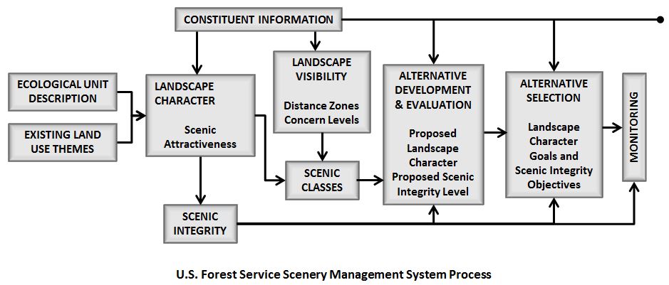
The SMS approach involves the following steps, as shown in the figure above:
- A Landscape (Scenic) Character Description is developed from the Ecological Unit Description for a planning area. The Landscape Character Description provides the frame of reference for defining the Scenic Attractiveness classes. Note: As part of the 2012 Planning Rule which guides Forest Service Planning processes, landscape character is referred to as "scenic character".
- Scenic Attractiveness classes are developed to determine the relative scenic value of lands within a particular landscape character.
- An Existing Scenic Integrity Inventory is conducted; scenic integrity indicates the degree of intactness and wholeness of the landscape character. Inventoried scenic integrity levels reflect current conditions of scenic resources. Desired scenic integrity levels can be developed as part of alternatives in Forest Planning and once adopted, become scenic integrity objectives (SIOs).
- A Constituent Analysis is conducted to determine forest users’ perceptions of attractiveness, to help identify special places, and to define the meaning people give to places within the area. The constituent analysis results are expressed as Concern Levels for particular locations within the area.
- Landscape Visibility is determined and mapped. Landscape visibility addresses the relative importance and sensitivity of what is seen and perceived in the landscape. It includes both human values as they relate to the relative importance to the public of various scenes, and the relative sensitivity of scenes based on distance from an observer.
- Seen Areas and Distance Zones are mapped for the locations with specific concern levels to determine the relative sensitivity of scenes based on their distance from an observer.
- Scenic Class Ratings are assigned to the areas, using the scenic attractiveness, landscape visibility, and concern level areas information. The numerical Scenic Class Ratings indicate the scenic value of landscape areas. Mapped scenic class values are used to compare the value of scenery with the value of other resources.
- A Landscape Value map is prepared using overlays of all the data gathered. The map provides information to planning teams concerning the relative scenic values of a subject area and the extent to which those values are intact. This information is used in the forest planning process, in which inventoried scenic values are compared with other resource values to determine desired future conditions via forest plan alternatives. Once a plan is adopted desired scenic integrity levels become official scenic integrity objectives (SIOs) with associated standards and guidelines for maintaining or enhancing current conditions.
These SMS processes are described in more detail on the USFS Visual Resource Inventory page of this website.